IMPORTANCE OF MAPS
GLOBES AND MAPS
A globe is a model of the earth. It shows us the true shape of the earth. It helps us to learn many important facts about the earth. But we can't always use a globe to complete all our purposes. Also, we can't make a globe as big as we like. We can't carry it with us everywhere. These difficulties can be overcome by the use of maps.
A map is a drawing on a flat surface. It can be drawn on paper or any flat surface. It can be drawn on a board or on a wall. We can make maps of any size. We can make maps of any place. There can be maps of the whole world. There can be maps of countries, cities, towns, villages and even classrooms.
A map can be very handy. It doesn't occupy much space. It can be folded or rolled. It can be carried easily in a travel bag or pocket. Maps can be of different kinds. They can be used in books. That is why maps are used more than globes.
No doubt, maps can't provide us a true picture of the earth. They are flat while the earth is round like a ball. Still, maps are of great use. They can give us much useful information. They can tell us at a glance-
1. The political boundaries of different countries.
2. The course of rivers, roads, railways, airways, etc.
3. The distribution of forests, crops, minerals, industries, etc.
4. The location of towns, cities, hills, plains, mountains, valleys, plateaus, etc.
It is not possible to show all these details on a globe. But, on a map, we can show even the minutest detail.
There are special books that have only maps in them. Such a book of maps is called an Atlas. A good atlas can give us all sorts of information. It can tell us about the political boundaries, the physical features and the natural resources of different parts of the world. It can also tell us about the vegetation and climatic conditions of different regions.
The Language of Maps
In order to read a language we first have to master its alphabet. Maps, too, have there own language. To read a map correctly, we must first learn the alphabet of the map language.
The alphabet of this language has various signs, symbols and colours. These symbols are used to make a map.
Finding Directions on a Map
There are four main directions. There are the North, the South, the East and the West. It is very easy to find these direction.
Stand with your face towards the rising sun. To your left , it is the North. To your right, it is the South. To the side of the sun, it is the East. To the opposite side, it is the West. These directions are fixed. All maps follow these directions. Apart from the four main directions, there are four sub-directions.
They are North-East, North-West, South-East and South-West. The North-East is midway between the North and the East. The North-West is midway between the North and the West. The South-East is midway between the South and the East. The South-West is midway between the South and the West.
If we know any of the four main directions, we can at once decide the other directions. In all maps, the top always shows the North. It is usually indicated by an arrow. The letter N is labelled at the tip of the arrow.
Finding Directions on a Map
Spread a map in front of you. Look at the side opposite to you and farthest from you. It is the North. Opposite to the North is the South. It is nearest to you. To your right is the East. To your left is the West.
There is another method.
Hand the map on a wall. The top of the map shows the North. The bottom shows the South. To your right is the East. To your left is West.
Scale of the Map
A map can never be as big as the area or region shown by it. It is much smaller. So a scale has to be used to draw a map. Scale means the ratio between the actual distance on the earth and the distance on the map. The scale used in map is always shown in a corner of the map. Take an example:
Suppose there are two places A and B on the earth. The actual distance between them is 100 kilometers. But on a given map, the distance between them is 1 centimetre. Then we will say that the scale of the map is 1 cm : 100km.

The scale of a map can be shown in another way. We call it linear scale. A line is drawn in a corner of the map. It is divided into equal parts. Each part indicates the actual distance on the ground. Look at the scale shown below:
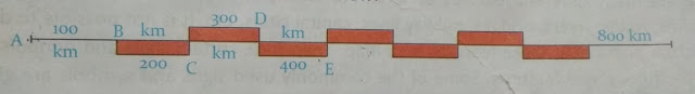
AB, BC, CD, DE ...... are equal lengths shown on the line. Each length denotes a distance of 100km on the ground. The starting point A indicates zero. According to this scale, a distance equal to the line AB is equal to 100km on the ground. A distance equal to the line AC is equal to 200km on the ground.
Thus by the use of a scale, we can know the actual ground distance between two places. A map not drawn according to scale is called a sketch.
The Colour Scheme
Some maps are in different colours. The different colours in a map indicate different land-forms and water bodies. The colour scheme of all coloured maps is almost always the same.
1. The blue colour indicates seas, oceans, rivers, lakes, etc.
2. The pale blue colour indicates shallow waters.
3. The deep blue colour indicates deep waters.
4. The green colour indicates low lands.
5. The yellow or the light brown colour shows plains that are higher than low lands.
6. The deep brown colour shows high lands and mountains.
Each coloured map carries a key or index. It shows how muh height or depth from the sea level each colour indicates. Can you match the colours used in the above map of India with those given in the key? Can you tell what each colour indicates?
The Use of Signs and Symbols
There are many different features on land. For example, there are temples, mosques, churches, roads, rivers, bridges, railways lines, capital cities, etc. It is not possible to draw the actual pictures of these features on a map. Therefore, certain signs and symbols are used to show these features. Some of the commonly used signs and symbols are given below:

Maps are very useful as they give us useful information about different regions, countries etc.
After reading this chapter you can get answers of below questions from here :
1. What is an Atlas?
2. How do maps help us?
3. What are the four major directions?
4. Why are various colours used in a map?
5. How is a map more useful than a globe?
6. How will you find the directions on a map?
7. How does the scale shown on a map help us?
8. Which is more accurate - a map or a globe?


0 Comments